Trail Walking Conamara Municipal District - Maumturks  - Photo
 heb
heb

User

© OpenStreetMap contributors
Length
Length
11.7 km
Max alt
Max alt
690 m
Uphill gradient
Uphill gradient
746 m
Km-Effort
Km-Effort  
22 km
Min alt
Min alt
55 m
Downhill gradient
Downhill gradient
747 m
Boucle
Boucle
Yes
Creation date :
2017-06-30 00:00:00.0
Updated on :
2017-06-30 00:00:00.0

(1 Reviews)

Walking
Walking
4h22
Difficulty : Difficult

Scan this QR Code to open this trail in the SityTrail application

FREE GPS app for hiking

Logo SityTrail SityTrail

IGN / Geographical institutes

Download SityTrail from the App Store Download SityTrail from Google Play

Logo SityTrail SityTrail World

The world is yours!

Download SityTrail from the App Store Download SityTrail from Google Play Download SityTrail on Huawei AppGallery

About

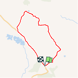
Trail Walking of 11.7 km to be discovered at Unknown, County Galway, Conamara Municipal District. This trail is proposed by heb.

Description

twelfe bens. Une randonnée en boucle au départ du parking de Maumeen   pics des Maumturk Mountain. Ce parcours n'est pas balisé.  

Elevation profile

Positioning

Country:
Ireland
Region :
Unknown
Department/Province :
County Galway
Municipality :
Conamara Municipal District
Location:
Illion Electoral Division
Start:(UTM)
455544 ; 5926298 (29U) N.

Comments

Please log in to post a review or rate the element


Trails nearby

Trail Walking Conamara Municipal District - Irlande 4 - Photo
Walking
jeanyvesjacquetton

Walking

Easy
Conamara Municipal District, Unknown, County Galway, Ireland
17.3 km | 20 km-effort
5h 16min
No


Close
My subscriptions